
Schoolhouse Flats: A Landscape in Motion


Stand in the hills above the Pedernales today and it is easy to imagine that what surrounds you has always looked much the same. Limestone. Cedar. Oak. River. But landscapes have histories too.
In the years after the Civil War, much of this part of the Texas Hill Country was more open than the landscape we know today. Native grasses spread across broad savannas, with trees concentrated along creeks, springs and the Pedernales. Fire moved through those grasses—sometimes lightning started it, sometimes people did. Long before Anglo settlement, Indigenous people understood fire as part of living with this landscape. It cleared old growth, encouraged new grasses and helped keep woody plants from overtaking the open country.
Then other people arrived and began making homes. By the 1870s, several families had settled on farms and ranches in what would eventually become Pedernales Falls State Park. They raised cattle and hogs. They planted crops. They built stone walls and fences. They traveled by wagon to Cypress Mill for mail, supplies and the cotton gin. And because families had children, they built a school.
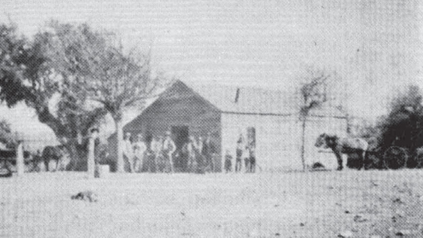
It was a small wood-framed building, roughly twelve by twenty feet—small enough that today we might mistake it for a shed. But to this little community, it was something much larger. Children learned there. Greene Wilson, a Methodist minister on whose land the school stood, apparently held church services there as well. Families buried their dead in a small cemetery nearby. Beside the schoolhouse was an open meadow that became known as Schoolhouse Flats. There, neighbors gathered. And they played baseball.
It's a wonderfully ordinary detail. It is easy to look backward and turn early settlers into characters from history—farmers, ranchers, pioneers. But on Schoolhouse Flats they were simply people. Children learned. Adults worked. Families prayed. Neighbors visited. Someone hit a baseball and someone else presumably had to go find it in the grass. For a while, this was home.
And all around them, the landscape continued doing what landscapes do. Changing.
The settlers had arrived during relatively wet years. Springs were abundant enough that the country around Cypress Mill and the Pedernales was remembered for its remarkable water. Then the rains became less dependable. Drought came during the 1880s and again in the 1890s. Crops failed. Springs diminished.
The land was changing in quieter ways too. Fences changed how livestock moved. Cattle grazed grasses that had once grown tall across the savanna. Fires became less frequent. Without the same cycle of grass, grazing and fire, woody plants found new opportunities. Ashe juniper—what Texans generally call cedar—spread, and the open country slowly became something different.
There was no single morning when anyone could have stepped outside and said, The landscape has changed. It happened the way so much change happens. A little less grass. A few more trees. A spring that didn't run quite as strongly. Another dry year. Another family leaving.
By the end of the nineteenth century, the community around Schoolhouse Flats had largely disappeared. The school closed. Farms and ranches were sold and gradually assembled into larger properties, and eventually much of the land became part of the Circle Bar Ranch. The schoolhouse disappeared. The baseball games stopped. The cemetery remained. The river kept moving.

And then came September 1952. Central Texas had been suffering through severe drought when extraordinary rain fell across the Pedernales watershed. The river rose. Not gently. At the Circle Bar Ranch, on land that would later become Pedernales Falls State Park, accounts describe a wall of water estimated at sixty to one hundred feet high. Downstream near Johnson City, the Pedernales reached an estimated peak flow of 441,000 cubic feet of water every second.
The river moved boulders. It snapped enormous trees. Cypress trees nearly one hundred feet tall were torn from the riverbanks, and a massive cypress log was later found lodged in oak trees roughly eighty feet above the riverbed. The flood deposited huge quantities of sand below the falls, creating a beach about 150 yards long and covering springs that had once been visible. In a matter of hours, the river rearranged a landscape that drought had spent years changing.

And then the water receded. The ranch carried on. Plants grew. Trees returned. The river resumed looking like a river. Eventually the Circle Bar Ranch became Pedernales Falls State Park, and visitors arrived to experience what was described as beautiful untouched wilderness.
But it wasn't untouched. It had simply changed again. Beneath today's trails are old wagon roads. Behind the cedar are echoes of grassland. A familiar crossing still carries the name of a family that once lived there. And somewhere in the landscape is the memory of a tiny schoolhouse and a meadow where neighbors once played baseball.
Perhaps the story of Schoolhouse Flats isn't about people changing the land or nature taking it back. It is about something less tidy. Everything participates in the change. People build houses, schools, churches and fences. Cattle graze. Grass grows. Fire moves. Rain doesn't come, and then sometimes it comes all at once. Rivers rise. Trees fall. Seeds germinate. Children grow up. Families leave. Other people arrive.
Every generation is tempted to believe the landscape it inherited is simply the landscape. The families of Schoolhouse Flats knew open savanna and abundant springs. Later generations knew ranch country. Visitors today know cedar, limestone, trails and the Pedernales winding through the park. All of them were looking at the same place. None of them saw its final version. There isn't one.
For a little while, we make our homes in the middle of it. And the river keeps moving.
Inspired by What Grows Wild.
Leffler, John J. Farmers, Ranchers, the Land and the Falls: A History of the Pedernales Falls Area, 1850-1970. Texas Parks and Wildlife Department, 2010.


Comments